The Big Bend Critical Linkage
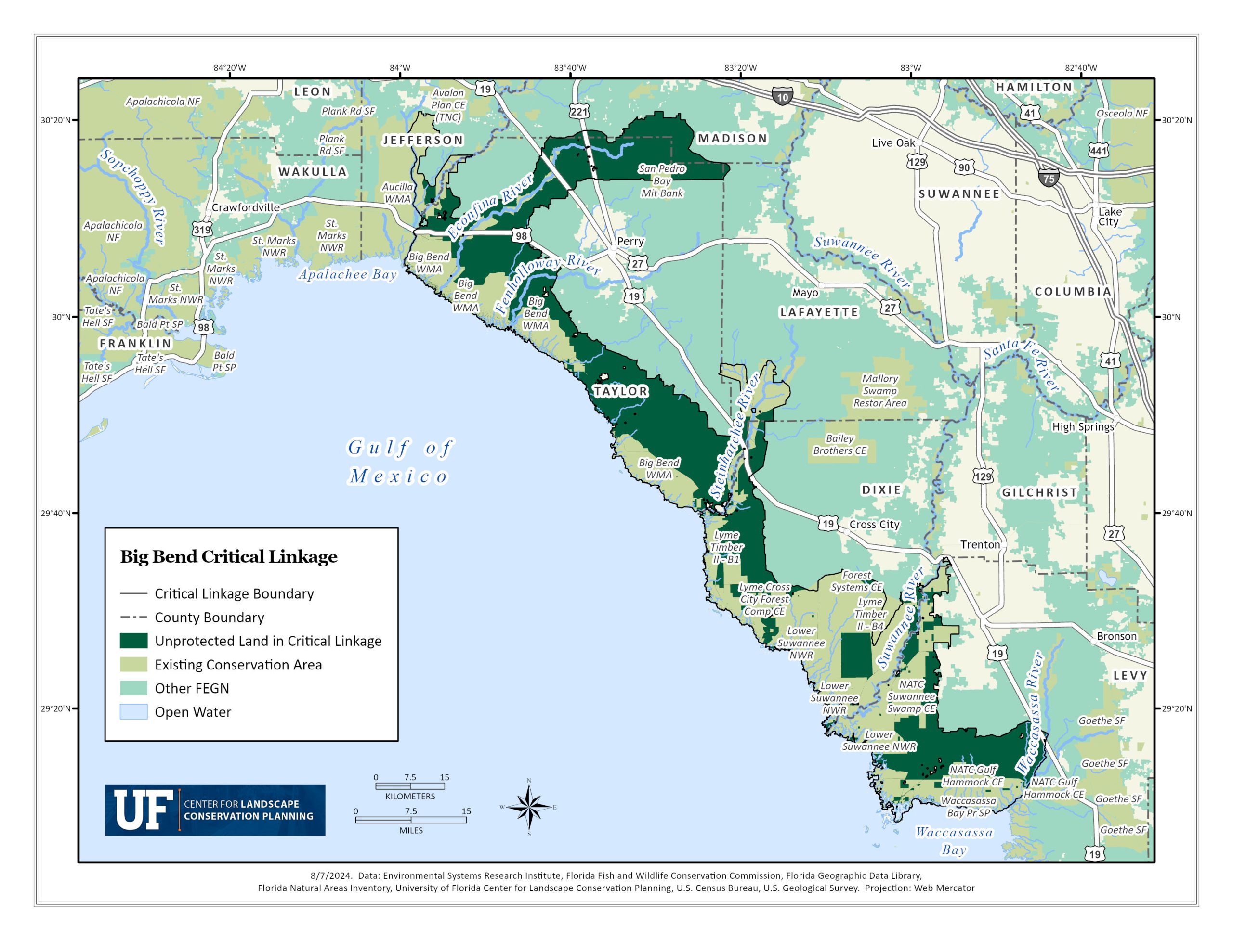
Situated in the Big Bend region of Florida, the “Nature Coast” lives up to its name due to the pristine ecosystems and the rural communities intrinsically tied to them. Spanning from the outstanding waterways of the Wacissa and Aucilla Rivers south to Waccasassa Bay and Goethe State Forest, the 100 miles of Big Bend Critical Linkage can help preserve gulf-side coastal resources, protect rural coastal communities from intensifying weather, sea level rise and urbanization pressures, while continuing to support the local economy and recreational destinations unique to “the bend.”

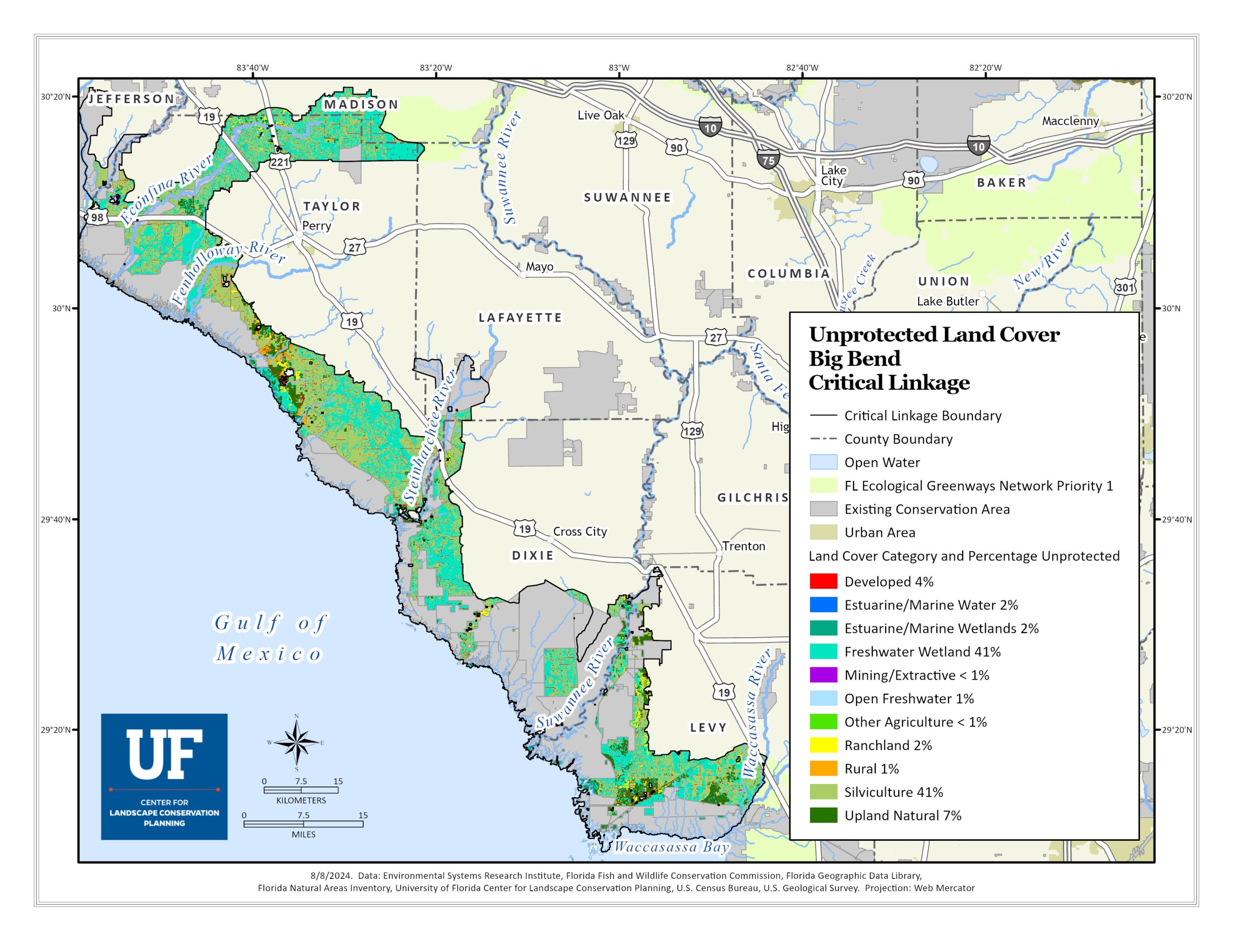
The linkage’s unprotected land is comprised of approximately 40% pine plantation and 41% freshwater wetland ecosystems; tidal creeks and marshes, freshwater springs, hydric hammocks, mesic flatwoods, swamps and freshwater marshes. Both these types of land covers are essential for managing water quality and quantity; they assist in managing stormwater from intense storms and ensure high-quality surface water that feeds the sensitive estuarine ecosystems that are dependent on clean water and replenish the Floridan Aquifer. Although not a natural ecosystem, timberlands that grow slash, loblolly, and sand pine are an extremely important component of Florida’s economy, rural character and conservation initiatives such as the FEGN. Timberland in the Big Bend provide ecosystem services such as timber production, carbon sequestration, wildlife habitat and corridors, as well as surface water infiltration. They can often be operated as a less intensive commercial land use in comparison to intensive agriculture or development that is not compatible with the ecosystem services current timberlands provide. In addition, these plantations can be restored into more natural ecosystems, such as original longleaf pine habitat; an important consideration as they face challenges from intensifying and more frequent storm events that can damage the timber crop.
Expansive salt marshes and seagrass meadows, buffered by oyster bars and sandy keys in the Gulf of Mexico are the dominant habitats along the Big Bend coast. This linkage is one of Florida’s best examples of natural lands that act as buffers against major storm events. It also holds the most potential out of anywhere in Florida for coastal habitats to adapt and migrate inland due to sea level rise. Coastal retreat is often a challenge due to human-made barriers, but due to the Big Bend linkage’s predominantly rural land use, there is a significant natural and uninterrupted interface between the freshwater uplands and wetlands to the coastal wetlands and seagrass preserves. Carbon sequestration, shoreline stabilization and reduced coastal erosion, stormwater management and water quality regulation, increased landscape biodiversity, and supporting tourism, recreation and fisheries production are just some of the ecosystem services the natural communities of the big bend provide. Ample opportunity for coastal retreat also enables the region’s flora and fauna to adapt and survive to sea level rise and a changing climate.
The Big Bend is one of the largest and most productive areas for marine shellfish in the Gulf of Mexico (IFAS), and the coastal community’s culture and local economy is intertwined with aquaculture. From pre-European settlement when the Apalachee Indians fished and harvested the Salt marshes and gulf, to the “watermen” of today who’s crab traps, boats, and scallop bags are iconic identifiers in town, the livelihood of those who live in this region is historically tied to the coastal resources that thrive in pristine estuarine ecosystems. Blue crab, oyster, shrimp, bay scallops, stone crabs, hard clams, and various species of fish are just some of the shellfish species important to the Big Bend economy. These shellfish require clean water and a healthy ecosystem to survive, meaning the success of these coastal communities and the integrity of the ecosystem are dependent on the preservation of the natural environment. Recreation; such as scalloping, fishing, bird watching, and exploring the vast network of water and land trails, is an iconic activity for locals and visitors alike.

Unprotected Land Cover Map for the Big Bend Linkage
The future of the linkage is dependent on the protection of currently unprotected land within this FEGN / Florida Wildlife Corridor priority one region. This map provides a breakdown of the types of unprotected land cover in the Big Bend linkage.

